The HuntStand App
HuntStand has spent the last 10 years developing an indispensable toolset for hunting, habitat management and land ownership. We’ve combined advanced mapping, premium satellite layers and dozens of useful features to create something that has revolutionized the way millions of Americans hunt.


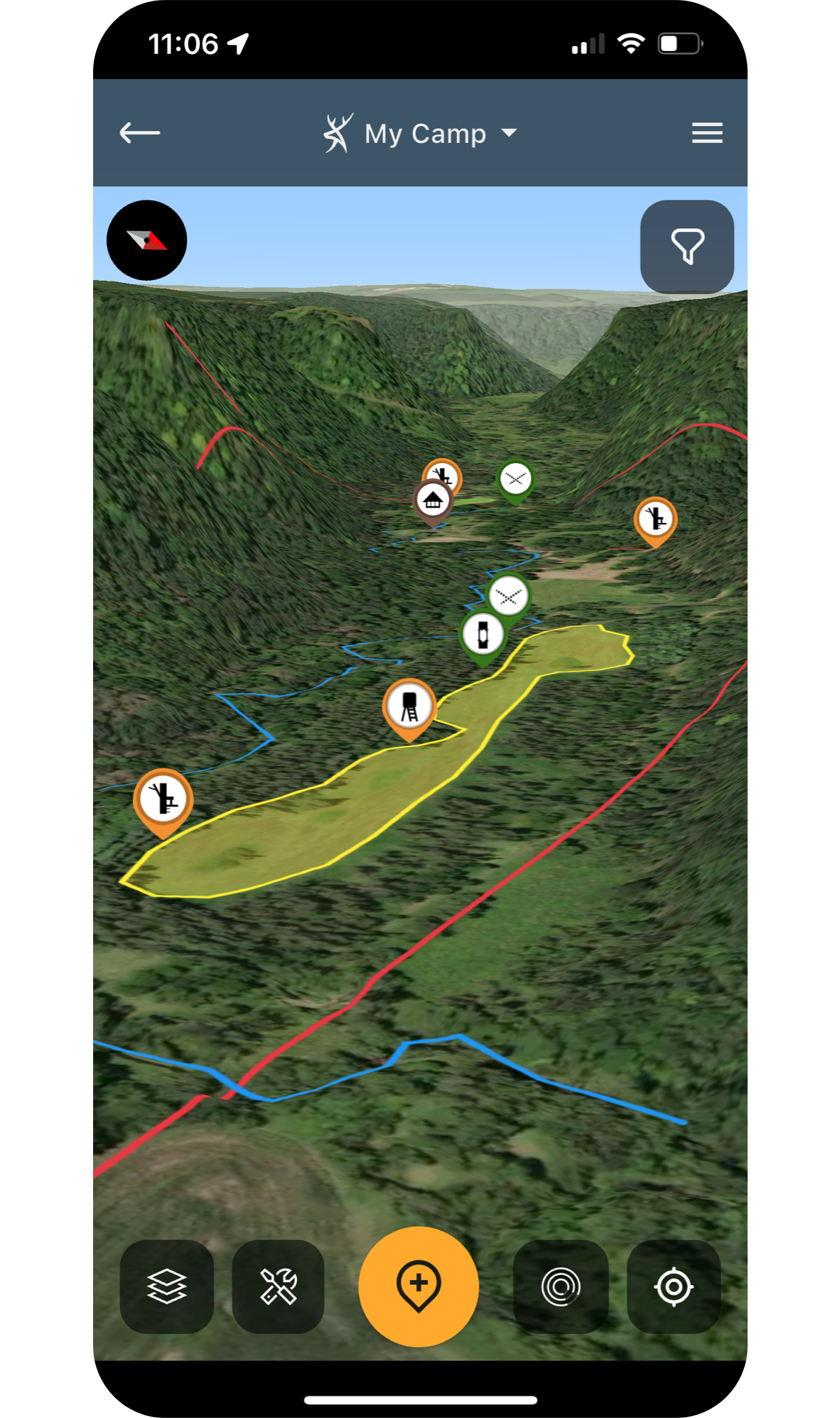
Preparation is Key
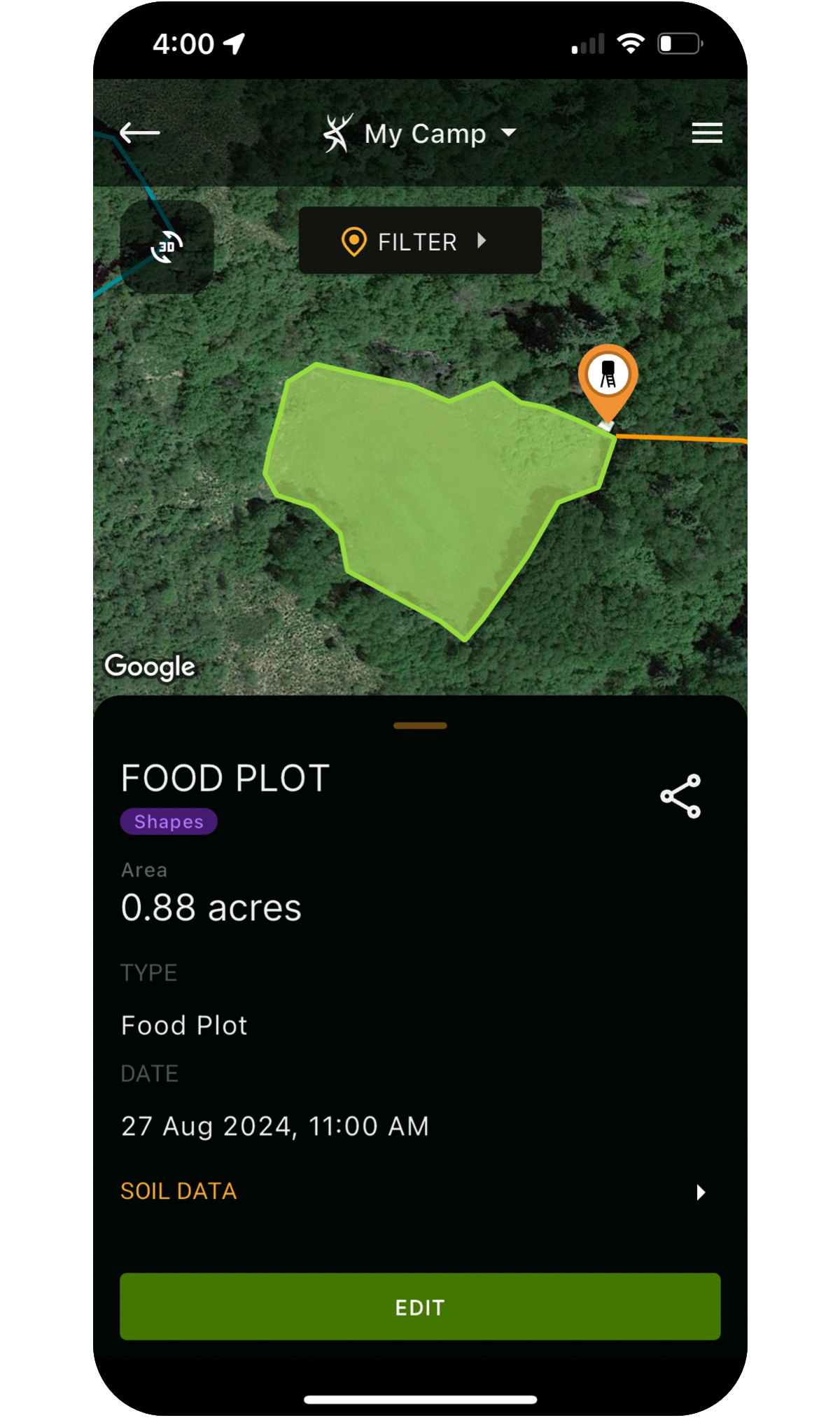
HuntStand offers the most comprehensive and powerful mapping features out there. Utilizing our exclusive tools you can build detailed and vivid maps of the areas you hunt.
- Draw lines showing roads, trails, paths, fences and other features.
- Create shapes showing boundaries, food plots, sanctuaries, water and more.
- View your map objects over 7 different base layers.
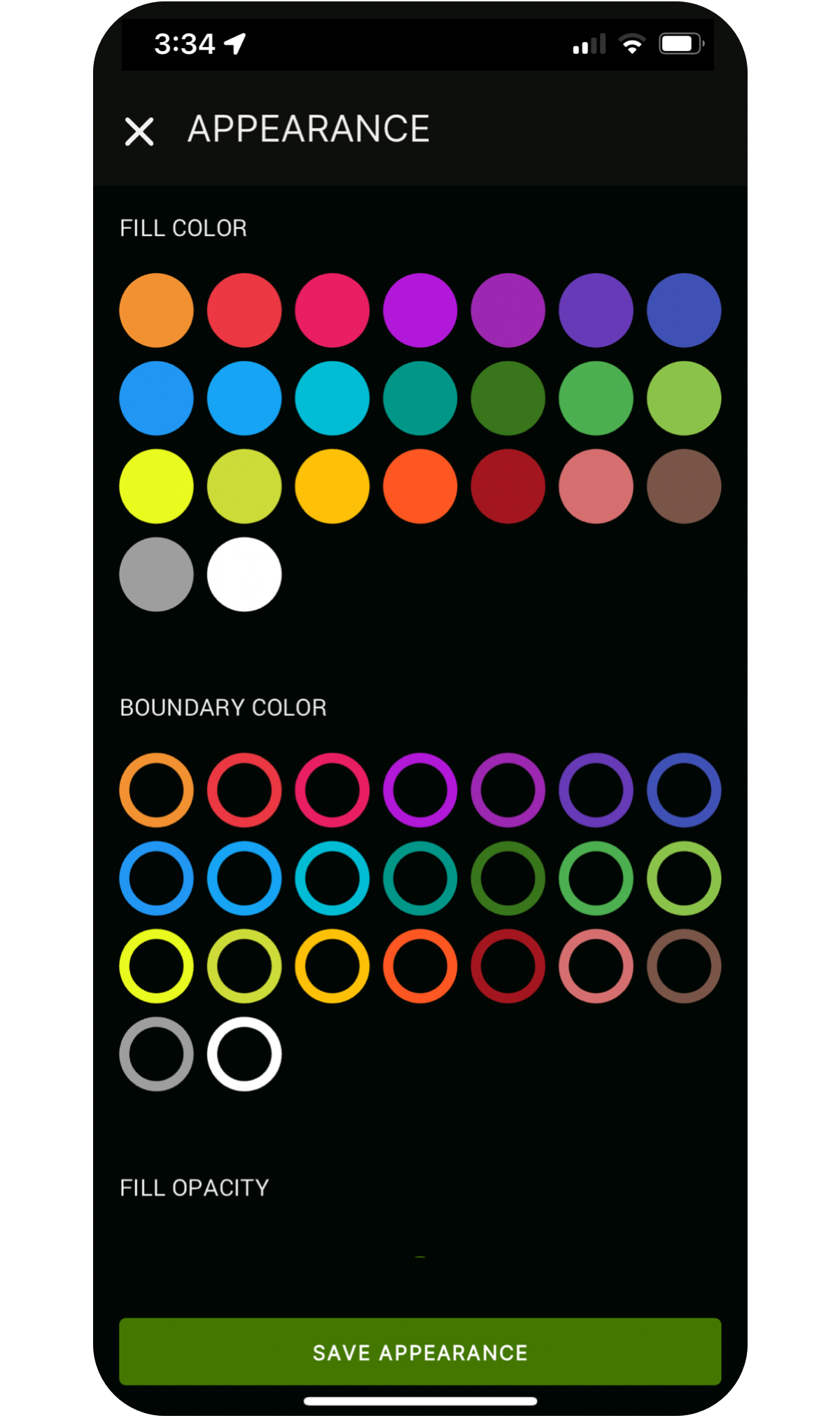
Make Your Mark
Complete your map by dropping and labeling markers to show points of interest.
- Mark stands, blinds, feeders, parking, structures and more.
- Over 50 different icons are available.
- Over 20 colors are also available.
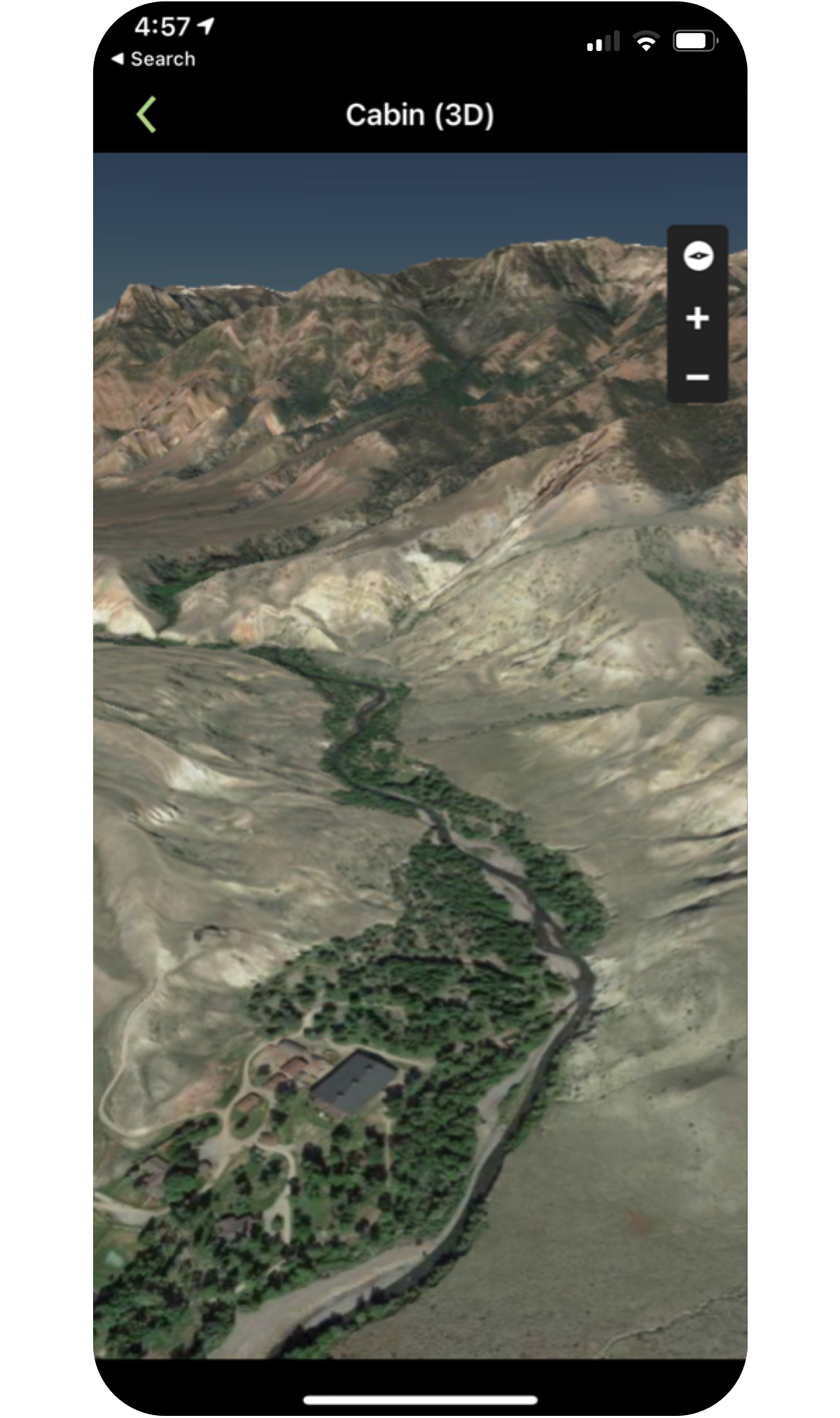
Birds' Eye Views
Experience the most advanced 3D hunting maps available on any device — iOS, Android, or desktop.
- Reveal ridges, valleys, and elevation changes with precision.
- Plan backcountry hunts using markers, shapes, and custom map tools.
- Pan, zoom, and rotate to virtually fly through your hunt area before you step into the field.
Unlimited Nationwide Property Data
By combining thousands of sources, we’ve created the most detailed nationwide database of private and public land made specifically for hunters:
- View detailed property boundaries (U.S. and most of Canada)
- View the owner’s name while mapping (U.S. only)
- Access detailed ownership information with a single tap (U.S. only)
- Search nationwide by owner name, address, county, acreage and more.
- Access detailed public hunting land maps, including allowable uses.
To see available property data by county/state/province click here.
UPGRADE TO PRO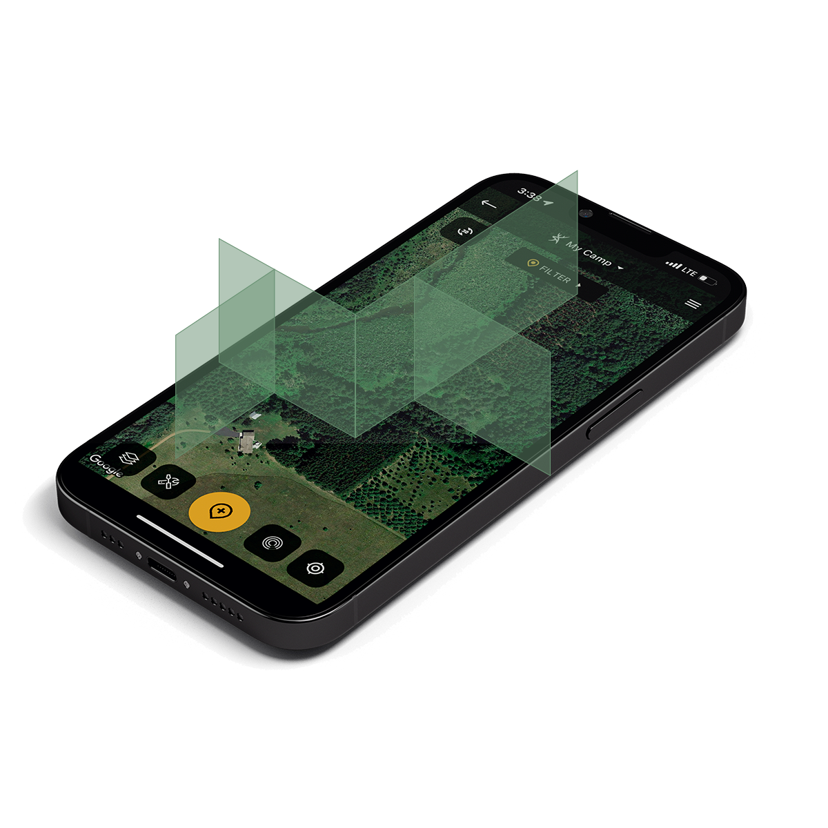
Measurement Made Easy
Easy to use tools allow you to instantly measure the distance between two points, or the area of any shape.
- Perfect for planning seed and fertilizer for food plots.
- Distance measurement is great for planning parking, positioning and shot distances.
- Feet, yards, meters and acres are available.
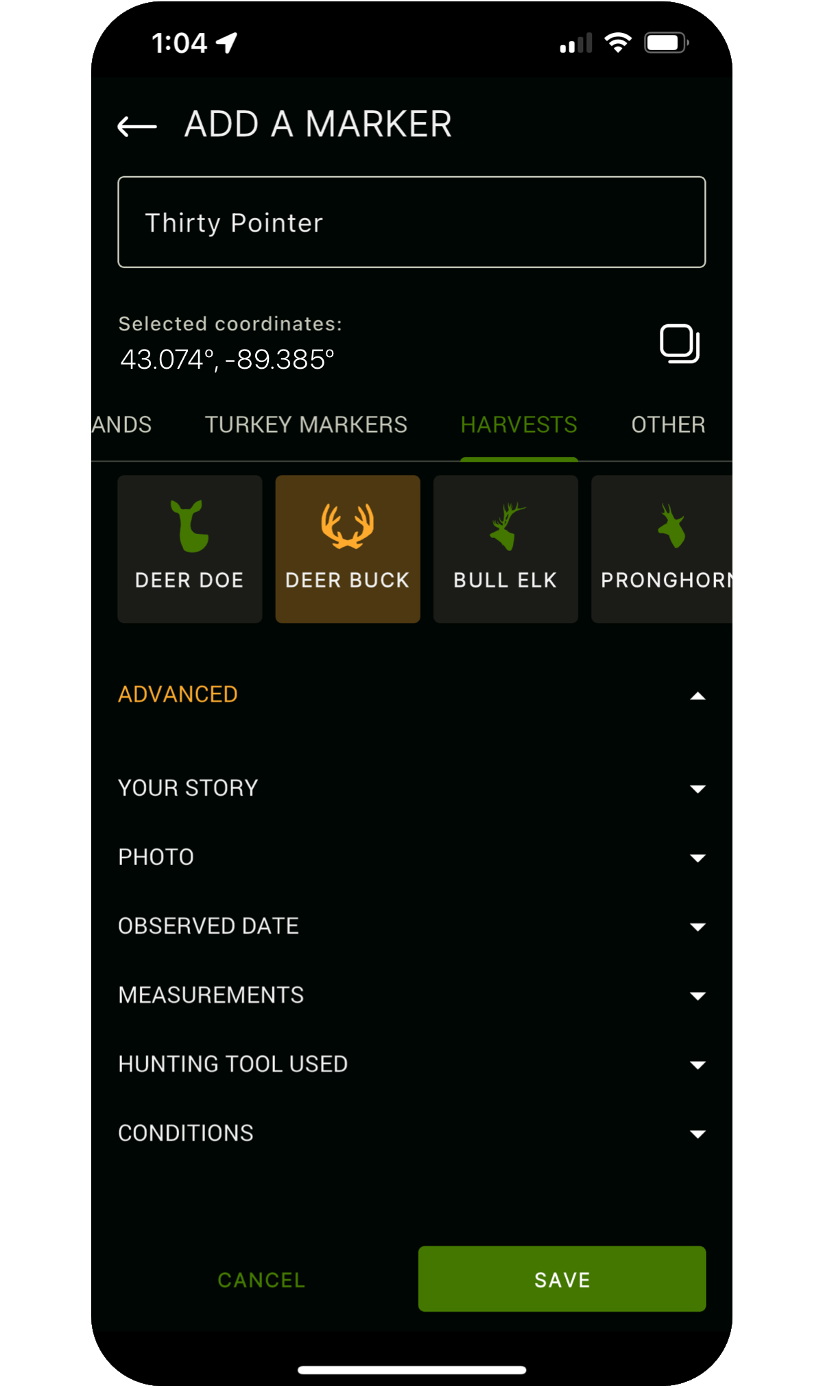
Your Record Keeper
Store detailed records of all your harvests in HuntStand with the push of a button.
- Select from a wide range of species with matching map markers.
- Enter notes and details in the story field.
- HuntStand will automatically include time, solunar and weather data to help inform future hunt planning.
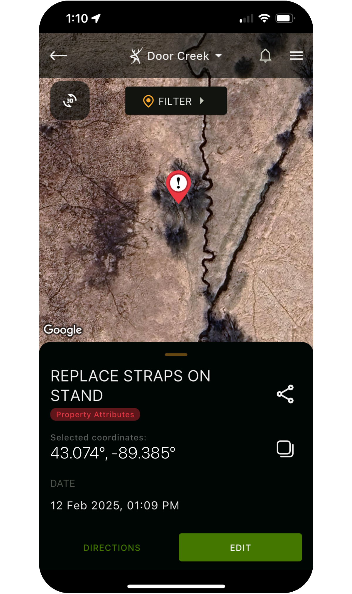
Your "Hunter do List"
HuntStand enables you to record tasks, to do lists and other details against map markers, food plots and more.
- Great for planning pre-season maintenance or noting issues while in the field.
- Choose from dozens of markers and 20 colors.
- View a complete list, pending or completed items.
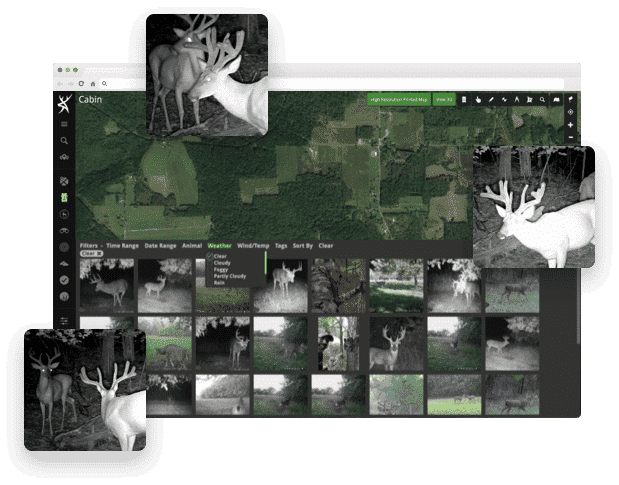
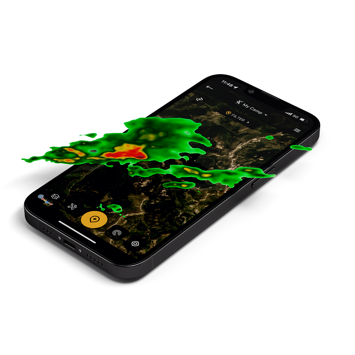
Trail cameras can be work, make them work for you.
HuntStand offers the best trail camera management functionality out there!
- Connect Command Pro to manage Stealth Cam and Muddy trail cameras.
- Easily share Command Pro cameras with Group Hunt Area members.
- Upload photos to sync with weather and solunar information. (Desktop only)
- AI species recognition spots and tags game for you. (Desktop only)
- Generate a heat map that shows you trail camera activity by location. (Desktop only)

Read the Wind
HuntZone’s proprietary algorithm uses advanced wind mapping to show your scent impact.
- Calculated using wind speed, direction and time of day.
- Use HuntZone at your current location or to pick a stand.
- Available for current time, or up to 72 hours in advance.
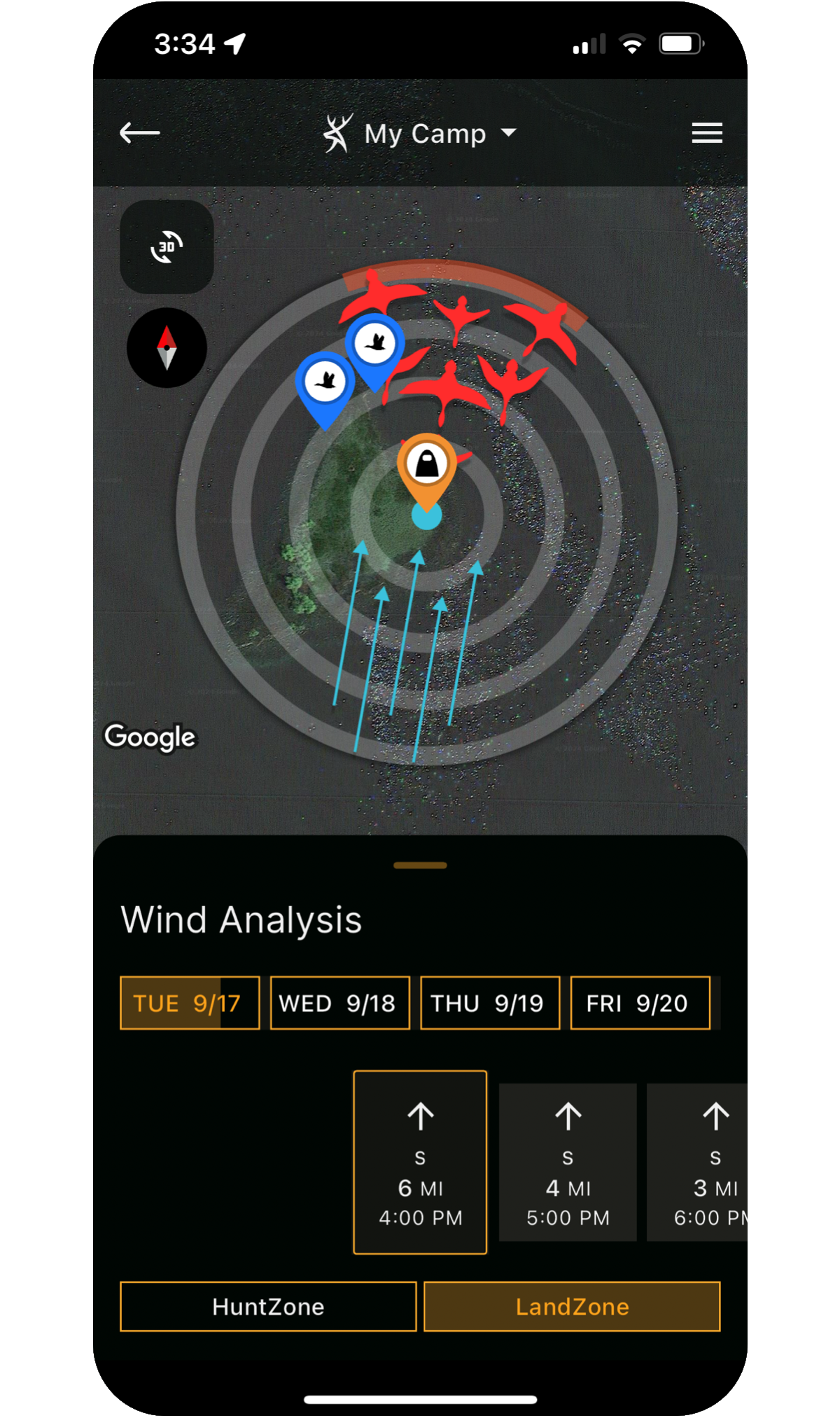
Your Flight Path
Similar to HuntZone, HuntStand’s LandZone uses advanced wind prediction algorithms to determine the direction that waterfowl will land from.
- Calculated using wind speed, direction and time of day.
- Use LandZone to improve your decoy setups and blind placement.
- Available for current time, or up to 72 hours in advance.
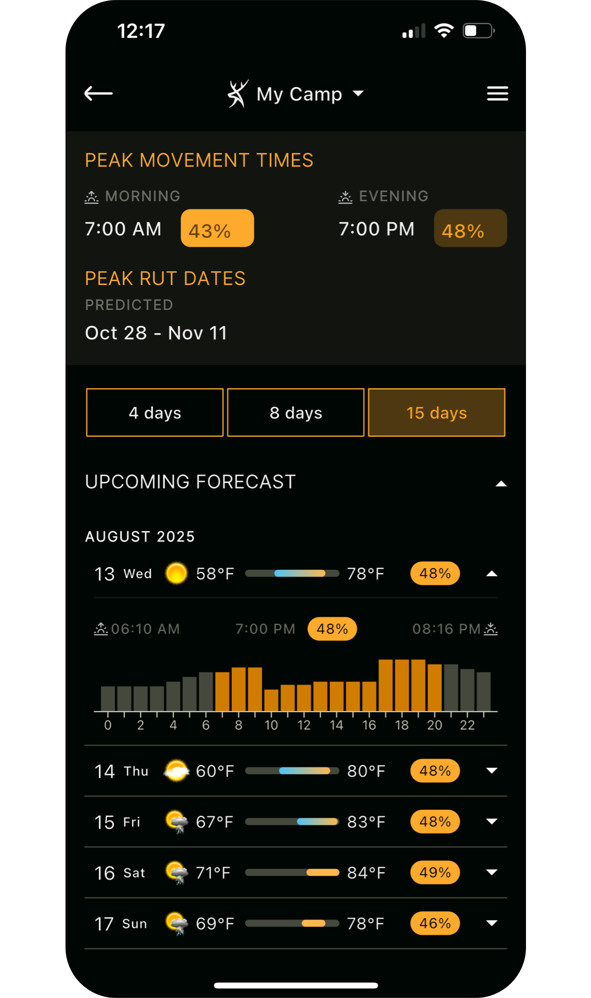
Forecast Game Movement
Get movement predictions built with input from leading wildlife biologists and real-world behavior.
- Advanced algorithms developed by deer and big-game biologists.
- Decades of data from wildlife studies across North America.
- 15-day activity forecasts for whitetail, elk, mule deer, and blacktail.
- Visualize weather impacts with detailed charts and graphs.
Monthly imagery, from space to your fingertips.
Traditional aerial imagery is only updated every 2-3 years, leaving a major blindspot for hunters and outdoor enthusiasts. We are the first app to offer monthly satellite imagery. This layer is lower resolution than traditional aerial imagery, but trades clarity for recency.
This is perfect for viewing:
- Timber thinning / clear cuts
- Fires and burns
- Flooding
- Agricultural activity
- Snow and ice cover
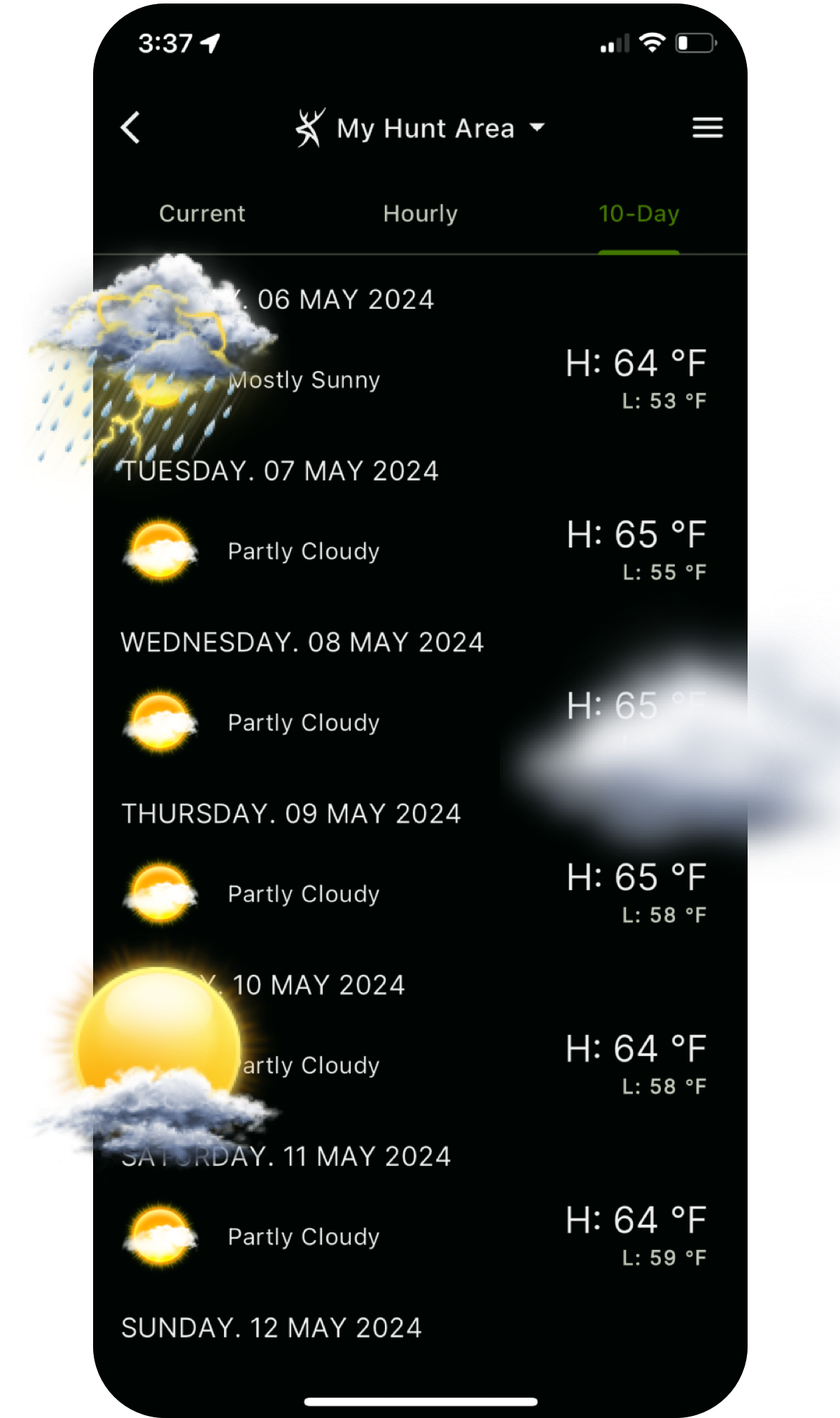
Don't Get Caught in the Rain
HuntStand provides up-to-date weather conditions and forecasts for your selected hunt area, including graphs and detailed views highlighting critical hunting related items.
- Current weather
- 72 Hour Weather list view and graph
- 5 day detailed forecast
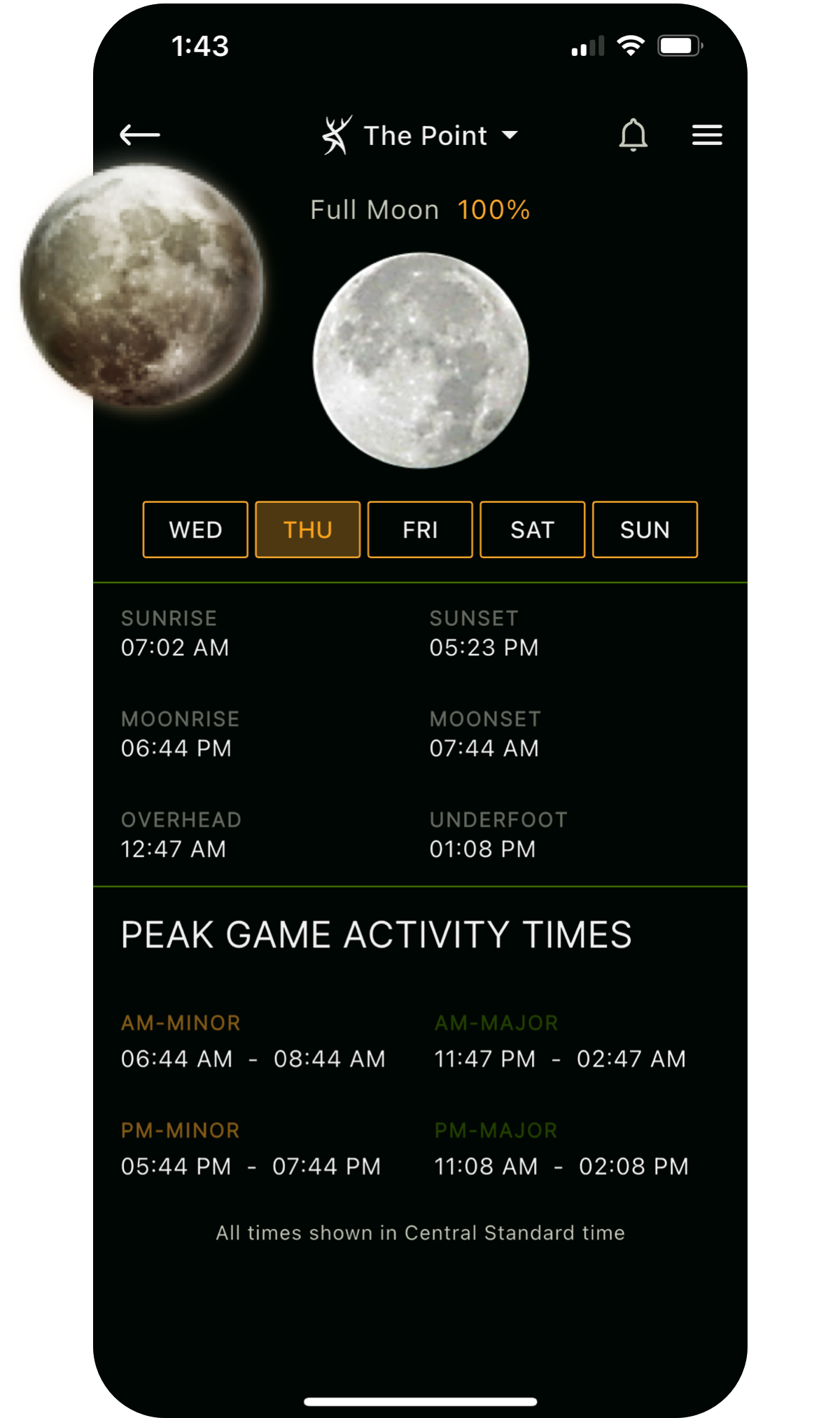
Key Solunar Insights
HuntStand has detailed solunar forecasts to give you critical information on potential game activity.
- Sunrise and sunset.
- Moonrise and moonset.
- Major and minor AM & PM feeding times.
Detailed Weather Maps
HuntStand offers universal weather overlays showing current and forecasted conditions. Available weather overlays include:
- Radar
- Precipitation
- Snow accumulation
- Temperatures
- Fires
- Drought Monitor
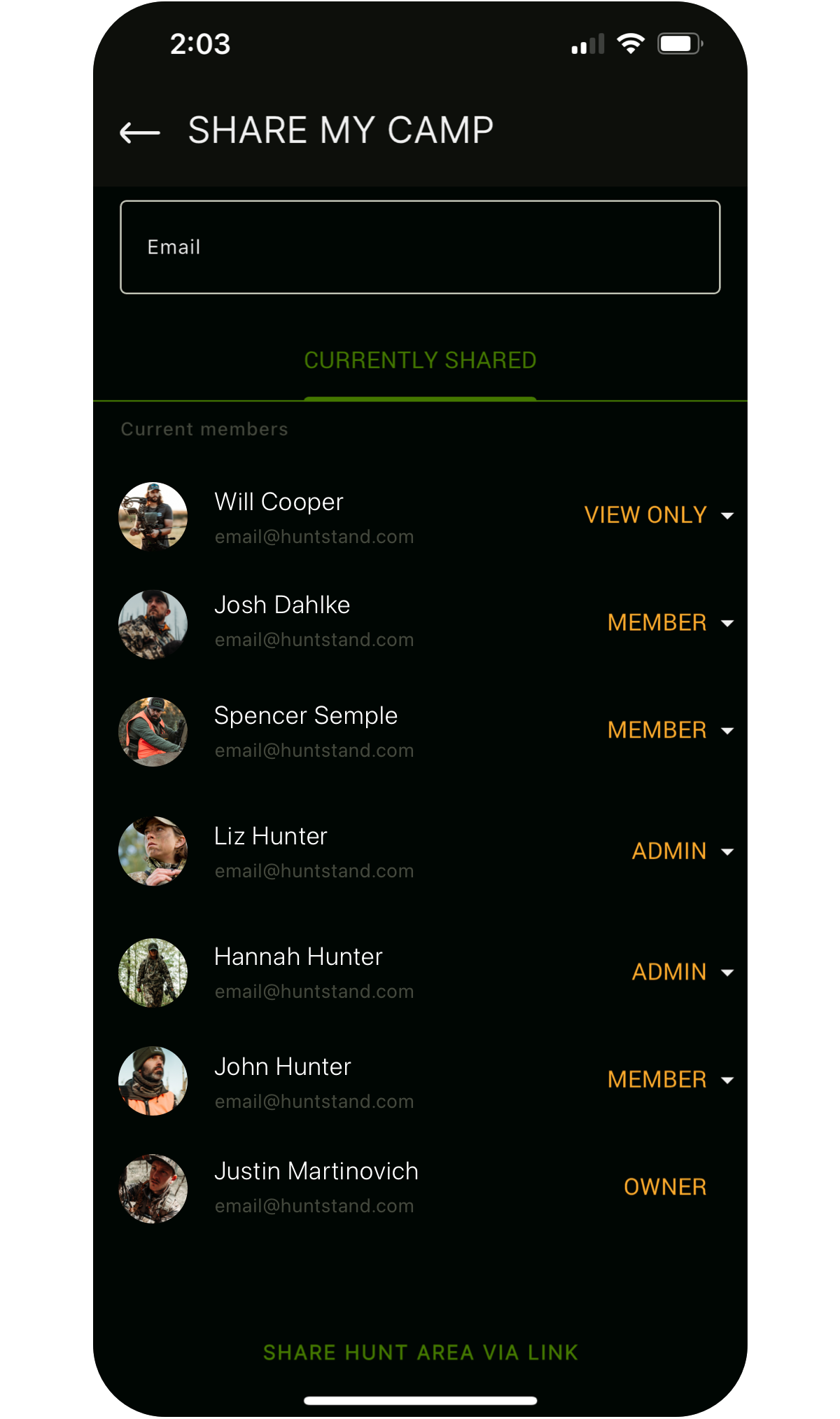
It's Better with Friends
Create a group hunt area by inviting your friends or club members to view your map.
- Control access levels.
- Sync map or hunt area changes so everyone is on the same page.
- Use HuntStand Pro’s unique stand reservation system.
- Utilize a group board, news feed and more.
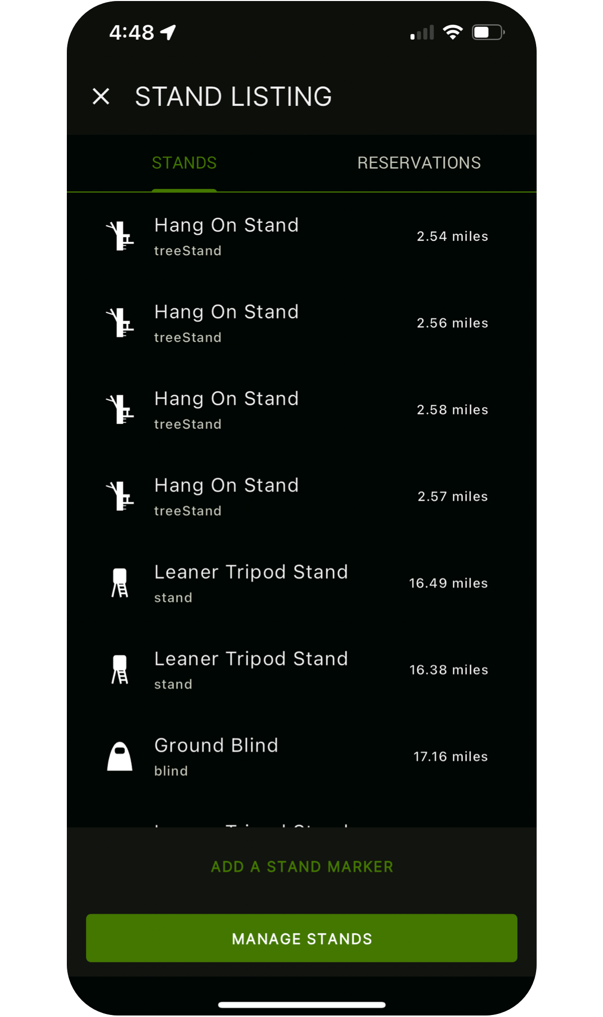
Reserve Your Stand
HuntStand Pro users get access to a robust stand reservation system that can help you and your club manage stands more efficiently:
- Reserve a stand for a specific time slot.
- View upcoming reservations for a specific stand or all stands in a group hunt area.
- Search for available stands/blinds in a hunt area by date or time.
- See what stands are currently occupied and by whom.
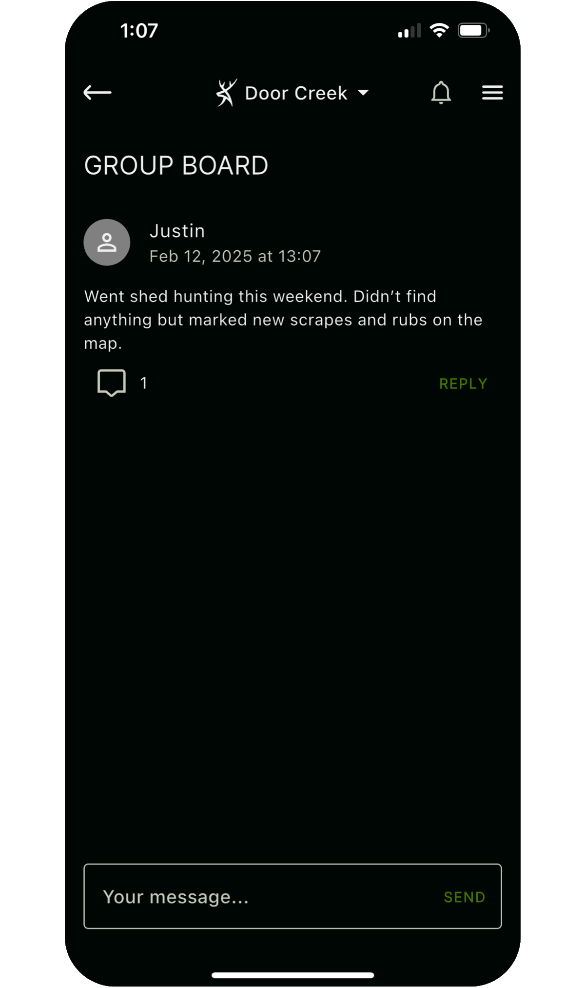
Keep Your Group Organized
Keep your group hunt area organized with a group message board and newsfeed!
Upgrade to HuntStand Pro
Unlock Powerful Premium FeaturesUpgrade to HuntStand Pro to unlock powerful tools made by hunters for hunters:
- Nationwide property data (U.S. and most of Canada)
- Nationwide public hunting lands and allowable uses
- Monthly satellite imagery
- New 3D Mapping
- Premium mapping layers
- Trail camera management
- Stand reservation management
- Unlimited offline maps
- An ad-free experience


The HuntStand App
HuntStand has spent the last 10 years developing an indispensable toolset for hunting, habitat management and land ownership. We’ve combined advanced mapping, premium satellite layers and dozens of useful features to create something that has revolutionized the way millions of Americans hunt.
Preparation is Key
HuntStand offers the most comprehensive and powerful mapping features out there. Utilizing our exclusive tools you can build detailed and vivid maps of the areas you hunt.
- Draw lines showing roads, trails, paths, fences and other features.
- Create shapes showing boundaries, food plots, sanctuaries, water and more.
- View your map objects over 7 different base layers.
Make Your Mark
Complete your map by dropping and labeling markers to show points of interest.
- Mark stands, blinds, feeders, parking, structures and more.
- Over 50 different icons are available.
- Over 20 colors are also available.
PRO
Birds' Eye Views
Experience the most advanced 3D hunting maps available on any device — iOS, Android, or desktop.
- Reveal ridges, valleys, and elevation changes with precision.
- Plan backcountry hunts using markers, shapes, and custom map tools.
- Pan, zoom, and rotate to virtually fly through your hunt area before you step into the field.
PRO
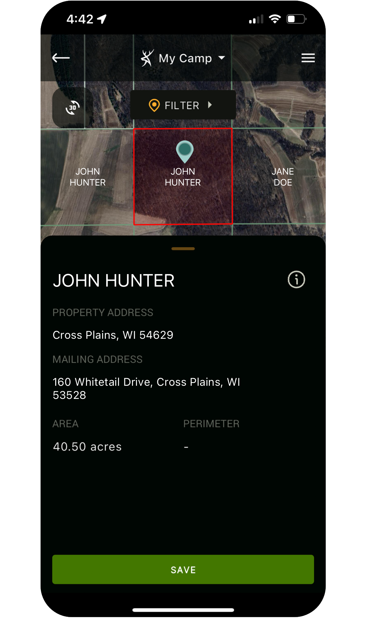
Unlimited Nationwide Property Data
By combining thousands of sources, we’ve created the most detailed nationwide database of private and public land made specifically for hunters:
- View detailed property boundaries (U.S. and most of Canada)
- View the owner’s name while mapping (U.S. only)
- Access detailed ownership information with a single tap (U.S. only)
- Search nationwide by owner name, address, county, acreage and more.
- Access detailed public hunting land maps, including allowable uses.
To see available property data by county/state/province click here.
UPGRADE TO PRO
Measurement Made Easy
Easy to use tools allow you to instantly measure the distance between two points, or the area of any shape.
- Perfect for planning seed and fertilizer for food plots.
- Distance measurement is great for planning parking, positioning and shot distances.
- Feet, yards, meters and acres are available.
Your Record Keeper
Store detailed records of all your harvests in HuntStand with the push of a button.
- Select from a wide range of species with matching map markers.
- Enter notes and details in the story field.
- HuntStand will automatically include time, solunar and weather data to help inform future hunt planning.
Your "Hunter do List"
HuntStand enables you to record tasks, to do lists and other details against map markers, food plots and more.
- Great for planning pre-season maintenance or noting issues while in the field.
- Choose from dozens of markers and 20 colors.
- View a complete list, pending or completed items.
PRO
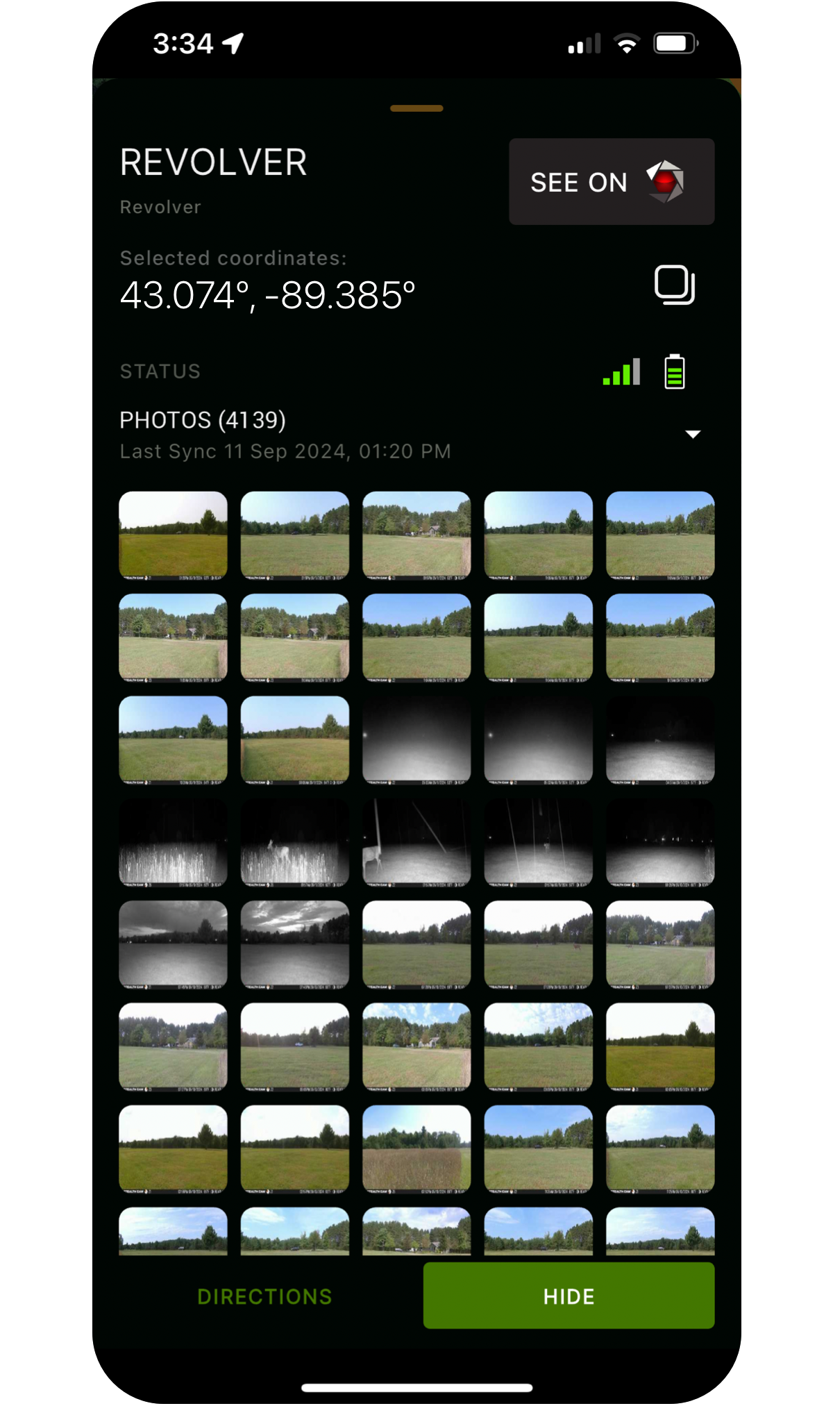
Trail cameras can be work, make them work for you.
HuntStand offers the best trail camera management functionality out there!
- Connect Command Pro to manage Stealth Cam and Muddy trail cameras.
- Easily share Command Pro cameras with Group Hunt Area members.
- Upload photos to sync with weather and solunar information. (Desktop only)
- AI species recognition spots and tags game for you. (Desktop only)
- Generate a heat map that shows you trail camera activity by location. (Desktop only)
Read the Wind
HuntZone’s proprietary algorithm uses advanced wind mapping to show your scent impact.
- Calculated using wind speed, direction and time of day.
- Use HuntZone at your current location or to pick a stand.
- Available for current time, or up to 72 hours in advance.
Your Flight Path
Similar to HuntZone, HuntStand’s LandZone uses advanced wind prediction algorithms to determine the direction that waterfowl will land from.
- Calculated using wind speed, direction and time of day.
- Use LandZone to improve your decoy setups and blind placement.
- Available for current time, or up to 72 hours in advance.
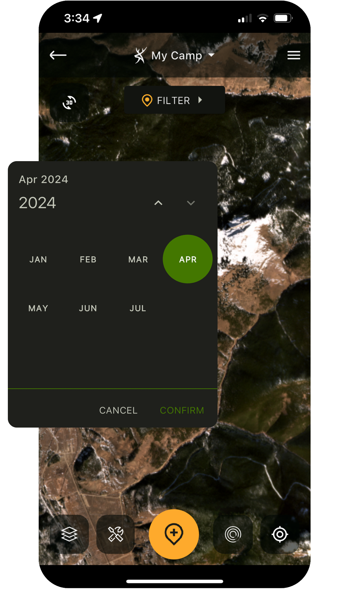
Forecast Game Movement
Get movement predictions built with input from leading wildlife biologists and real-world behavior.
- Advanced algorithms developed by deer and big-game biologists.
- Decades of data from wildlife studies across North America.
- 15-day activity forecasts for whitetail, elk, mule deer, and blacktail.
- Visualize weather impacts with detailed charts and graphs.
PRO
Monthly imagery, from space to your fingertips.
Traditional aerial imagery is only updated every 2-3 years, leaving a major blindspot for hunters and outdoor enthusiasts. We are the first app to offer monthly satellite imagery. This layer is lower resolution than traditional aerial imagery, but trades clarity for recency.
This is perfect for viewing:
- Timber thinning / clear cuts
- Fires and burns
- Flooding
- Agricultural activity
- Snow and ice cover
Don't Get Caught in the Rain
HuntStand provides up-to-date weather conditions and forecasts for your selected hunt area, including graphs and detailed views highlighting critical hunting related items.
- Current weather
- 72 Hour Weather list view and graph
- 5 day detailed forecast
Key Solunar Insights
HuntStand has detailed solunar forecasts to give you critical information on potential game activity.
- Sunrise and sunset.
- Moonrise and moonset.
- Major and minor AM & PM feeding times.
PRO
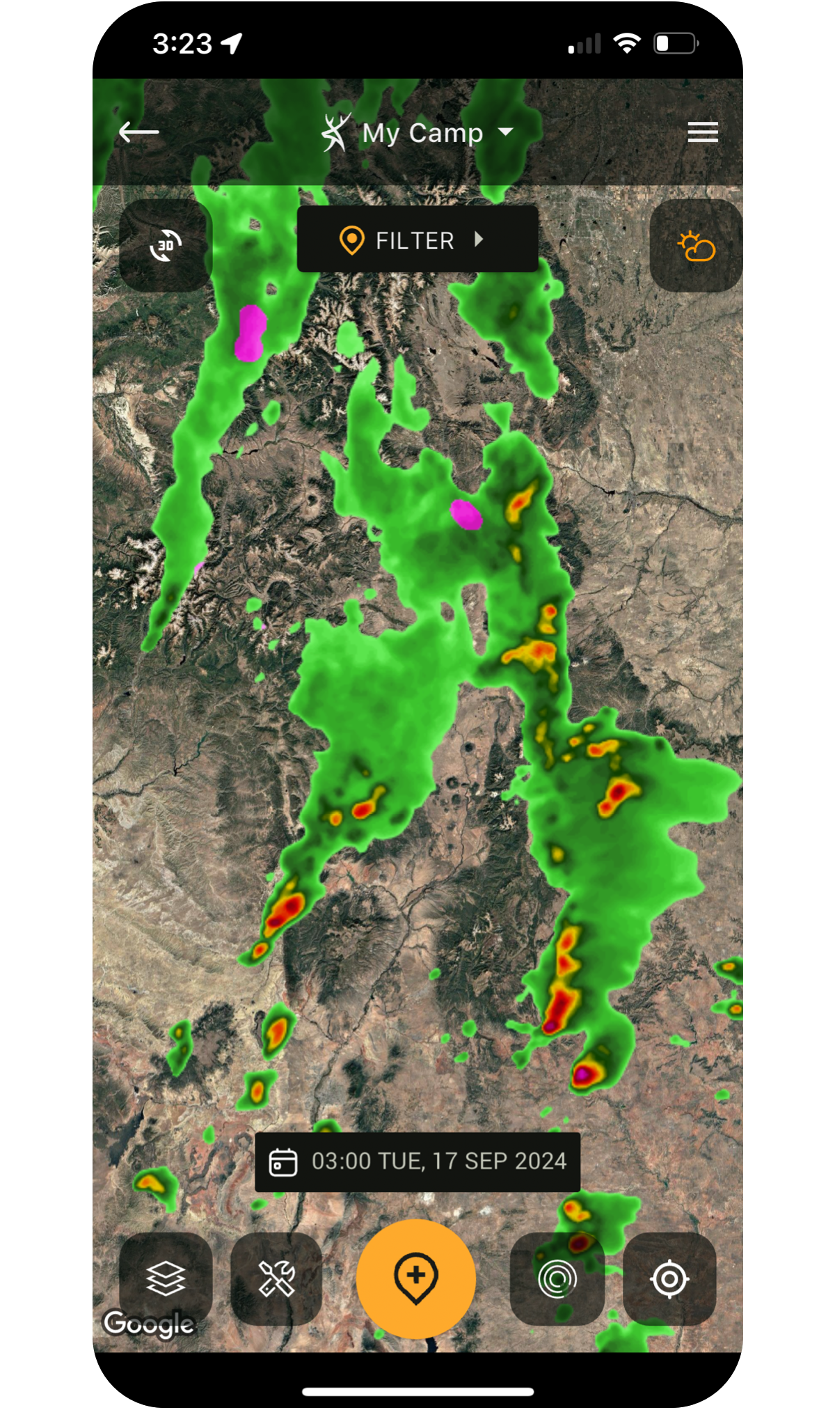
Detailed Weather Maps
HuntStand offers universal weather overlays showing current and forecasted conditions. Available weather overlays include:
- Radar
- Precipitation
- Snow accumulation
- Temperatures
- Fires
- Drought Monitor
It's Better with Friends
Create a group hunt area by inviting your friends or club members to view your map.
- Control access levels.
- Sync map or hunt area changes so everyone is on the same page.
- Use HuntStand Pro’s unique stand reservation system.
- Utilize a group board, news feed and more.
Reserve Your Stand
HuntStand Pro users get access to a robust stand reservation system that can help you and your club manage stands more efficiently:
- Reserve a stand for a specific time slot.
- View upcoming reservations for a specific stand or all stands in a group hunt area.
- Search for available stands/blinds in a hunt area by date or time.
- See what stands are currently occupied and by whom.
Keep Your Group Organized
Keep your group hunt area organized with a group message board and newsfeed!
PRO